
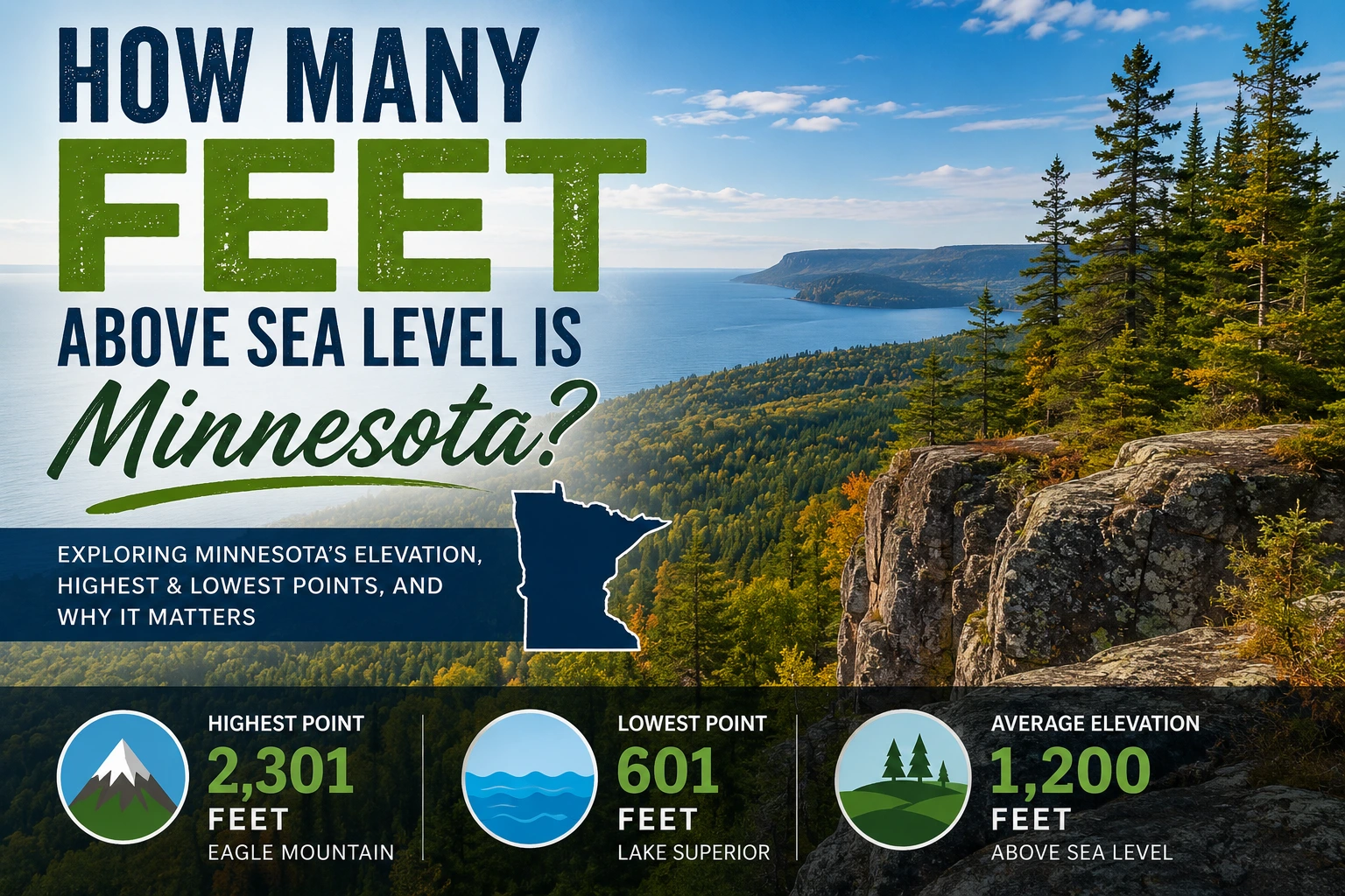
If you have ever wondered how many feet above sea level is Minnesota, the short answer is that the state has an average elevation of about 1,200 feet above sea level. However, the actual elevation changes significantly depending on where you are in the state. Some areas sit close to 600 feet above sea level, while others rise to more than 2,300 feet.
Minnesota is known for its lakes, forests, rolling hills, and northern wilderness. Its elevation plays an important role in shaping the state’s weather, environment, agriculture, and even outdoor recreation. Understanding Minnesota’s altitude also helps explain why some parts of the state are colder, wetter, or hillier than others.
In this guide, you will learn the average elevation of Minnesota, its highest and lowest points, how it compares with other states, and why elevation matters in everyday life.
Understanding Elevation and Sea Level
Before discussing Minnesota specifically, it helps to understand what elevation means.
What Does Above Sea Level Mean?
Elevation refers to the height of land compared to sea level. Sea level is considered the average level of the ocean’s surface and serves as the starting point for measuring altitude around the world.
For example:
- A city located 1,000 feet above sea level is 1,000 feet higher than the ocean surface.
- Areas below sea level are lower than the ocean’s average level.
Elevation is usually measured in feet in the United States.
How Elevation Is Measured
Scientists use advanced tools such as:
- GPS systems
- Satellite imaging
- Topographic surveys
- Geographic information systems (GIS)
These tools help create accurate elevation maps and terrain models.
How Many Feet Above Sea Level Is Minnesota?
Minnesota has an average elevation of approximately 1,200 feet above sea level. This makes it a moderately elevated state compared to the rest of the United States.
1200 feet above sea level
The elevation varies widely throughout Minnesota because the landscape includes:
- Flat plains
- Rolling hills
- Forested highlands
- River valleys
- Lake regions
Average Elevation of Minnesota
The average elevation is around 1,200 feet, but this does not represent every location equally. Southern and western Minnesota tend to have flatter land, while northeastern regions are much higher.
Elevation Range Across the State
Minnesota’s elevation ranges from:
- About 601 feet at its lowest point
- To 2,301 feet at its highest point
This difference creates diverse ecosystems and weather conditions across the state.
Highest Point in Minnesota
The highest point in Minnesota is Eagle Mountain.
Eagle Mountain Elevation
Eagle Mountain stands at 2,301 feet above sea level.
2301 feet above sea level
It is located in northeastern Minnesota near the Canadian border within the Superior National Forest.
Despite being the highest point in the state, Eagle Mountain is relatively modest compared to mountain peaks in western states like Colorado or California.
What Makes Eagle Mountain Unique
Eagle Mountain is popular for:
- Hiking
- Wildlife viewing
- Scenic forest landscapes
- Outdoor photography
The hiking trail is accessible for many visitors and offers stunning views of Minnesota’s wilderness.
Lowest Point in Minnesota
The state’s lowest point is located along Lake Superior.
Lake Superior Shoreline
Minnesota’s lowest elevation is approximately 601 feet above sea level at Lake Superior.
601 feet above sea level
Lake Superior itself is the largest freshwater lake by surface area in the world.
Why Minnesota Has Different Elevation Levels
Minnesota’s varied elevation is largely due to ancient glaciers that shaped the landscape thousands of years ago. Glacial movement carved valleys, formed lakes, and created rolling terrain.
This glacial history explains why the state contains:
- More than 10,000 lakes
- Rocky northern terrain
- Fertile southern plains
Minnesota Elevation Compared to Other States
Minnesota’s elevation is moderate compared to other U.S. states.
| State | Average Elevation |
|---|---|
| Minnesota | 1,200 feet |
| Florida | 100 feet |
| Texas | 1,700 feet |
| Colorado | 6,800 feet |
| Kansas | 2,000 feet |
| California | 2,900 feet |
Minnesota sits higher than low coastal states but much lower than mountainous western states.
Midwest Elevation Differences
Compared to nearby Midwest states:
- Minnesota is higher than Iowa
- Similar to Wisconsin
- Lower than South Dakota
These differences affect climate, snowfall, and drainage patterns.
Why Elevation Matters in Minnesota
Elevation influences many aspects of life in Minnesota.
Weather and Climate
Higher elevations are usually cooler. Northern Minnesota often experiences:
- Longer winters
- More snowfall
- Cooler summer temperatures
Lower areas near rivers and lakes may experience more humidity and fog.
Agriculture and Land Use
Southern Minnesota’s lower and flatter land is ideal for farming. Crops commonly grown include:
- Corn
- Soybeans
- Wheat
- Sugar beets
Higher and rockier northern areas are less suitable for large-scale agriculture.
Flooding and Water Drainage
Elevation affects how water moves across the land. Lower regions near rivers are more vulnerable to flooding during heavy rain or snowmelt.
Minnesota’s many lakes and rivers also depend on natural elevation changes for drainage.
Major Minnesota Cities and Their Elevation
Different cities in Minnesota have different elevations.
| City | Approximate Elevation |
|---|---|
| Minneapolis | 830 feet |
| Saint Paul | 795 feet |
| Duluth | 705 feet |
| Rochester | 1,004 feet |
Minneapolis
Minneapolis sits around 830 feet above sea level. Its elevation contributes to cold winters but does not create major altitude issues.
Saint Paul
Saint Paul, the state capital, is slightly lower in elevation than Minneapolis and lies along the Mississippi River.
Duluth
Duluth sits near Lake Superior. While the city itself is relatively low, nearby hills rise steeply and create dramatic views.
Rochester
Rochester has a higher elevation than many other Minnesota cities, sitting around 1,000 feet above sea level.
How Elevation Affects Daily Life
Most people in Minnesota do not notice major effects from elevation because the altitude is not extreme. However, elevation still influences several areas of life.
Health and Breathing
Minnesota’s elevation is generally too low to cause altitude sickness. High-altitude health problems usually occur above 8,000 feet.
This means visitors and residents can comfortably adapt to the environment.
Outdoor Activities
Elevation helps create excellent conditions for:
- Hiking
- Skiing
- Snowboarding
- Mountain biking
- Camping
Northern Minnesota’s hills and forests are especially popular for outdoor recreation.
Construction and Infrastructure
Engineers consider elevation when planning:
- Roads
- Bridges
- Drainage systems
- Flood prevention projects
Lower regions may require stronger flood management systems.
Interesting Facts About Minnesota’s Geography
Minnesota’s elevation is closely tied to its fascinating geography.
Lakes and Elevation
Minnesota is called the “Land of 10,000 Lakes,” although it actually has more than 11,000 lakes.
Elevation changes help water collect naturally in basins formed by glaciers.
Glacial History
Massive glaciers covered Minnesota during the Ice Age. As glaciers moved and melted, they created:
- Valleys
- Hills
- Lakes
- Rivers
This geological history shaped the state’s current elevation patterns.
Terrain Variations
Minnesota includes several terrain types:
- Forested highlands in the northeast
- Flat prairies in the west
- Rolling farmland in the south
- Wetlands and lake regions throughout the state
This variety makes Minnesota geographically diverse.
Common Misunderstandings About Minnesota Elevation
Many people assume Minnesota is completely flat because of its farmland and lakes. While some areas are flat, the state also contains hills, ridges, cliffs, and elevated forest regions.
Another misconception is that cold weather means high elevation. Minnesota’s cold climate is mainly due to its northern latitude rather than extremely high altitude.
Some travelers also believe all Midwest states have similar elevation, but each state varies significantly in terrain and altitude.
Expert Tips for Understanding Minnesota Elevation
Here are a few useful tips when learning about Minnesota’s altitude:
- Use topographic maps for detailed elevation data.
- Northern Minnesota generally has higher terrain.
- Lake Superior strongly influences nearby elevations and climate.
- Elevation affects snowfall and drainage more than daily breathing conditions.
- Average elevation numbers do not reflect local terrain differences.
Understanding these details provides a clearer picture of Minnesota’s geography.
Practical Uses of Elevation Information
Knowing Minnesota’s elevation can be useful for:
- Travelers planning hiking trips
- Homebuyers researching flood risks
- Students studying geography
- Farmers managing crops
- Builders designing infrastructure
- Outdoor sports enthusiasts
Elevation maps also help environmental scientists track climate and water movement.
9. FAQs
What is the average elevation of Minnesota?
Minnesota’s average elevation is about 1,200 feet above sea level.
What is the highest point in Minnesota?
Eagle Mountain is the highest point in Minnesota at 2,301 feet above sea level.
What is the lowest elevation in Minnesota?
The lowest point is Lake Superior at approximately 601 feet above sea level.
Is Minnesota considered a high-altitude state?
No, Minnesota has moderate elevation and is not considered a high-altitude state.
Does elevation affect Minnesota weather?
Yes, higher areas in northern Minnesota often experience cooler temperatures and more snowfall.
10. Conclusion
So, how many feet above sea level is Minnesota? The state has an average elevation of around 1,200 feet above sea level, with elevations ranging from 601 feet at Lake Superior to 2,301 feet at Eagle Mountain. Minnesota’s elevation may not be extreme, but it plays a major role in shaping the state’s climate, geography, agriculture, and outdoor lifestyle.
From rolling farmland to forested highlands, Minnesota offers a diverse landscape influenced by ancient glaciers and natural elevation changes. Whether you are researching geography, planning a trip, or simply curious about the state, understanding Minnesota’s elevation provides valuable insight into what makes the North Star State unique.
Discover more